A high-definition map1 is not a more detailed version of Google Maps. That distinction matters more than any other in this book, so we will say it plainly before anything else.
An HD map is a machine-readable description of a place, precise and structured enough that a robot can drive through it.
Google Maps is built for humans. An HD map is built for machines. The difference sounds small. It changes everything about how the map is made, what it contains, and why it is hard.
This book exists because that difference is easy to state and hard to act on. Much of what you already know about everyday maps does not transfer, and some of it actively gets in the way. So the first part of the book resets those instincts. By the end of it, every format and tool you meet later will have an obvious job, because you will know the problem it solves.
Why ordinary maps are not enough
Open a navigation app and you see roads, names, and turn arrows. That is plenty for a human driver. You bring the rest. You see the stop sign, you read the lane lines, you know that the faded yellow marking still means “do not cross,” and you ease around the double-parked delivery truck.
A robot brings none of that. A robot only knows what the map tells it, and what its sensors can measure in the moment. If the map does not describe the lane, the robot does not know the lane exists. If the map does not encode “this line is illegal to cross,” the robot has no reason to treat it as a boundary.
To make this concrete, meet Harbor Yard, a small logistics depot we will return to throughout this book.
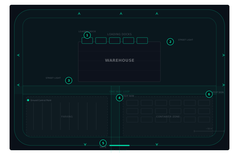 Harbor Yard has a row of loading docks, a one-way loop around the warehouse, and a faded stop line at the yard gate where a human driver once decided the line no longer mattered and started rolling through. A human handles all of that without thinking. A robot with the wrong map will drive the wrong way down the loop, or roll straight through that gate, because nothing in its world said not to.
So an HD map has to carry, in data, the things a human driver carries in their head.
What makes a map “high definition”
Three things separate an HD map from the maps you use every day.
Precision. A navigation app is happy if a road lands in the right place to within a few meters. An autonomous vehicle may need centimeters. A lane boundary that is off by 30 cm is a lane boundary the robot will cross, on a route it believes is correct.
Semantics. A line in an HD map is not just geometry. It is a lane boundary, a stop line, a crosswalk, a keep-clear zone. Each piece of geometry carries semantics, meaning the robot can act on. A line that says “stop here” and a line that says “this is only paint” have the same shape. Only the map tells them apart.
Rules and topology. The map says not only where things are, but how they connect and what is allowed. Which lane leads into which. Who has the right of way. Where the speed limit drops. A robot plans a path through this topology of meaning, not through a drawing.
The map is not the territory, but it has to be close
Every map is a simplification.2 The question for autonomy is how much simplification the robot can tolerate before it stops being safe. That is why HD maps exist at the resolution they do. They keep just enough of the physical world, in just enough detail, for a machine to act in it.
What an HD map is built from
Later parts of this book unpack each ingredient. For now, know that a production HD map is usually assembled from several representations working together: a point cloud for ground-truth geometry, a vector layer for lanes and boundaries, a set of rules for traffic and access, and a format like Lanelet2 to hold it all in a form an autonomy stack such as Autoware can consume.
One honest caveat: the formats move. As of this writing, Lanelet2 is the common language for the controlled environments this book focuses on, but the field is a moving target and newer efforts are nudging it along. We will treat the formats as they are today and flag where they are still in flux.
Where this book goes next
A robot trying to move through a place has to answer four questions: Where am I? What is around me? Where can I go? What am I allowed to do? The whole Handbook is organized around giving you the mental model to answer those four questions, and then the tools to build the map that encodes the answers.
That is the next chapter.
Footnotes
-
The term “HD map” is used loosely across the industry. Some people mean only the high-precision geometry; others mean the geometry plus the rules. In this book it means both: the full machine-readable description of a place. We pick that fight on purpose later on. ↩
-
The phrase “the map is not the territory” comes from Alfred Korzybski, in 1933. He was making a point about language and abstraction. We borrow it because it is exactly the problem autonomy lives with every second the vehicle is moving. ↩
Found an error or have a suggestion?
Report an erratum or send feedback →